Pages

Showing posts with label Ray Systems. Show all posts

Thursday, February 6, 2014

New Impact Crater in Syrtis Major Planum


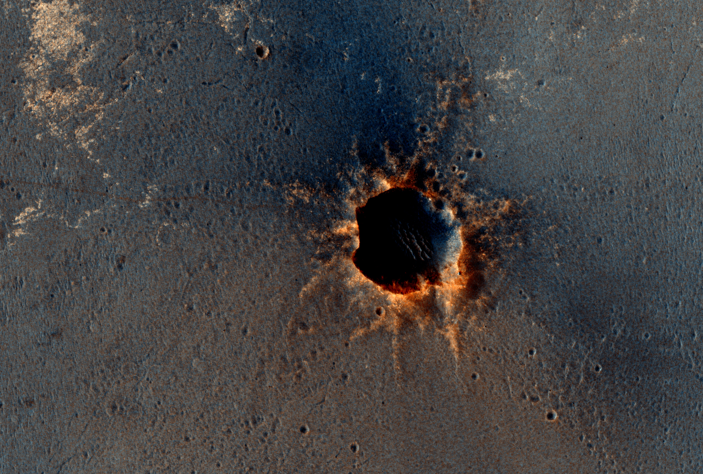
A dramatic, fresh impact crater dominates this image taken by the High Resolution Imaging Science Experiment (HiRISE) camera on NASA's Mars Reconnaissance Orbiter on November 19, 2013. Researchers used HiRISE to examine this site because the orbiter's Context Camera had revealed a change in appearance here between observations in July 2010 and May 2012, bracketing the formation of the crater between those observations.

The crater spans approximately 100 feet (30 meters) in diameter and is surrounded by a large, rayed blast zone. Because the terrain where the crater formed is dusty, the fresh crater appears blue in the enhanced color of the image, due to removal of the reddish dust in that area. Debris tossed outward during the formation of the crater is called ejecta. In examining ejecta's distribution, scientists can learn more about the impact event. The explosion that excavated this crater threw ejecta as far as 9.3 miles (15 kilometers).

The crater is at 3.7 degrees north latitude, 53.4 degrees east longitude on Mars. Before-and-after imaging that brackets appearance dates of fresh craters on Mars has indicated that impacts producing craters at least 12.8 feet (3.9 meters) in diameter occur at a rate exceeding 200 per year globally. Few of the scars are as dramatic in appearance as this one.

This image is one product from the HiRISE observation cataloged as ESP_034285_1835. Other products from the same observation are available at http://uahirise.org/ESP_034285_1835.

Image credit: NASA/JPL/University of Arizona

Note: For more information, see A Spectacular New Impact Crater and Its Ejecta and NASA Mars Orbiter Examines Dramatic New Crater. This crater is located in Syrtis Major Planum to the northwest of Schroeter Crater.

Tuesday, February 26, 2013

Mercury Global Map


A global color map of Mercury's surface has been created by mosaicking thousands of sets of images obtained by the MESSENGER Wide Angle Camera (WAC). The colors shown here are related to variations in the spectral reflectance across the planet. This view captures both compositional differences and differences in how long materials have been exposed at Mercury's surface. Young crater rays, arrayed radially around fresh impact craters, appear light blue or white. Medium- and dark-blue areas are a geologic unit of Mercury's crust known as the "low-reflectance material," thought to be rich in a dark, opaque mineral. Tan areas are plains formed by eruption of highly fluid lavas. The large circular area near the top center is the Caloris impact basin, whose interior is filled with smooth, somewhat younger volcanic plains. Small orangish spots are materials deposited by explosive volcanic eruptions.

The color base map shown here consists of MDIS images taken through eight different color filters. It is part of a global color map that covers more than 99% of Mercury's surface with an average resolution of about 1 kilometer per pixel.

Instrument: Wide Angle Camera (WAC) of the Mercury Dual Imaging System (MDIS). This is an enhanced-color presentation created from a statistical combination of images taken through eight of the WAC filters.

Video credit: NASA/Johns Hopkins University Applied Physics Laboratory/Carnegie Institution of Washington; text credit: NASA/Johns Hopkins University Applied Physics Laboratory/Carnegie Institution of Washington

Note: Available on the original NASA webpage are two different size maps available for download: a smaller 6.5 MB video and a larger 23 MB video.

Saturday, January 19, 2013

New Blue Impact Crater on Mercury


In the lower left portion of today's image is a small, young, rayed impact crater. The rays have a typical bluish cast in this color presentation. The relatively blue color in this case is caused partly by the extreme youth of the rays (surfaces exposed to the space environment of Mercury for long periods tend to "redden" and darken). In addition, the crater formed in a dark, bluish terrain called the "Low Reflectance Material." The tan area toward the top of the image is "intermediate terrain."

Date acquired: November 30, 2011
Image Mission Elapsed Time (MET): 231181189, 231181209, 231181193
Image ID: 1078917, 1078922, 1078918
Instrument: Wide Angle Camera (WAC) of the Mercury Dual Imaging System (MDIS)
WAC filters: 9, 7, 6 (996, 748, 433 nanometers) in red, green, and blue.
Center Latitude: -34.19°
Center Longitude: 133.6° E
Resolution: 647 meters/pixel
Scale: The small rayed crater is about 16 km (10 mi.) in diameter.
Incidence Angle: 54.9°
Emission Angle: 3.9°
Phase Angle: 58.7°

Photo credit: NASA/Johns Hopkins University Applied Physics Laboratory/Carnegie Institution of Washington

Friday, March 30, 2012

Bright Rays from Canuleia Crater


In this image from NASA's Dawn spacecraft, bright material extends out from the crater Canuleia on Vesta. The bright material appears to have been thrown out of the crater during the impact that created it.

Canuleia crater is located outside the rim of the Rheasilvia basin in the southern hemisphere, inside the quadrangle named for Urbinia crater. It is about 6 miles (10 kilometers) in diameter. The bright ejected material extends 12 to 19 miles (20 to 30 kilometers) beyond the crater's rim.

This image was obtained by Dawn's framing camera on October 25, 2011, during high-altitude mapping orbit (on average 420 miles or 680 kilometers above the surface). This particular image was obtained at an altitude of 435 miles (700 kilometers). It covers about 2,000 square miles (5,000 square kilometers).

Photo credit: NASA/JPL-Caltech/UCLA/MPS/DLR/IDA/UMD

Note: This is only one of fifteen images recently released about features on Vesta. Choosing just one image to highlight on this blog was rather difficult. Be sure to visit the JPL website to view the other fourteen images!

Wednesday, February 15, 2012

Kuiper Crater


This high-resolution enhanced color view of Kuiper crater shows not just the bright rays that extend out from this relatively young crater but also the redder color of Kuiper's ejecta blanket. The redder color may be due to a compositionally distinct material excavated from depth by the impact that formed Kuiper.

Date acquired: September 02, 2011
Image Mission Elapsed Time (MET): 223443634, 223443638, 223443654
Image ID: 708128, 708129, 708133
Instrument: Wide Angle Camera (WAC) of the Mercury Dual Imaging System (MDIS)
WAC filter: 9 (1000 nanometers), 7 (750 nanometers), 6 (433 nanometers) as red-green-blue
Center Latitude: -11.97°
Center Longitude: 328.4° E
Resolution: 380 meters/pixel
Scale: Kuiper has a diameter of 62 kilometers (39 miles)
Incidence Angle: 33.4°
Emission Angle: 21.4°
Phase Angle: 54.8°

Photo credit: NASA/Johns Hopkins University Applied Physics Laboratory/Carnegie Institution of Washington

Wednesday, January 4, 2012

The Bright Rays of Mena


The young rays of Mena crater contrast brightly against the surrounding surface, though the rays will gradually fade with time. The asymmetric pattern of the rays, with a gap in the south-western direction, may be due to the angle at which the impact that formed the crater occurred, or to the fact that Mena formed on the rim of a larger pre-existing impact crater, as seen in this image.

Date acquired: November 12, 2011
Image Mission Elapsed Time (MET): 229581348, 229581352, 229581356
Image ID: 1003074-1003076
Instrument: Wide Angle Camera (WAC) of the Mercury Dual Imaging System (MDIS)
WAC filters: 9, 7, 6 (1000, 750, 430 nanometers) as red, green, blue
Center Latitude: -0.97°
Center Longitude: 234.0° E
Resolution: 257 meters/pixel
Scale: Mena has a diameter of 15 km (9 miles)
Incidence Angle: 29.7°
Emission Angle: 16.3°
Phase Angle: 46.0°

Photo credit: NASA/Johns Hopkins University Applied Physics Laboratory/Carnegie Institution of Washington

Monday, August 1, 2011

Rembrandt Basin


The large Rembrandt basin is evident on the left side of this image, and, in contrast to the relatively darker material surrounding Rembrandt, Amaral crater and its bright rays can be seen on the right. Rembrandt basin is an area of particular scientific interest due to its large size, young age, and extensional and contractional characteristics. In fact, Rembrandt was highlighted in a publication of Science magazine in 2009 and featured on the cover.

This image was acquired as part of MDIS's color base map. The color base map is composed of WAC images taken through eight different narrow-band color filters and will cover more than 90% of Mercury's surface with an average resolution of 1 kilometer/pixel (0.6 miles/pixel). The highest-quality color images are obtained for Mercury's surface when both the spacecraft and the Sun are overhead, so these images typically are taken with viewing conditions of low incidence and emission angles.

Date acquired: July 11, 2011
Image Mission Elapsed Time (MET): 218833662, 218833682, 218833666
Image ID: 489008 , 489013, 489009
Instrument: Wide Angle Camera (WAC) of the Mercury Dual Imaging System (MDIS)
WAC filter: 9 (1000 nanometers), 7 (750 nanometers), 6 (433 nanometers) as red-green-blue
Center Latitude: -34.67°
Center Longitude: 100.4° E
Resolution: 1853 meters/pixel
Scale: Rembrandt basin has a diameter of 716 kilometers (445 miles).
Incidence Angle: 50.5°
Emission Angle: 0.4°
Phase Angle: 50.5°

Photo credit: NASA/Johns Hopkins University Applied Physics Laboratory/Carnegie Institution of Washington

Sunday, March 13, 2011

Opportunity is Still Smiling


The High Resolution Imaging Science Experiment (HiRISE) camera on NASA's Mars Reconnaissance Orbiter acquired this color image on March 9, 2011, of "Santa Maria" crater, showing NASA's Mars Exploration Rover Opportunity perched on the southeast rim.

The rover is the bluish speck at about the four o'clock position on the crater rim (with indicator arrow on Figure 1). North is up. Rover tracks are visible to the west of the crater.

Opportunity has been studying this relatively fresh, 90-meter-diameter (295-foot-diameter) crater to better understand how crater excavation occurred during the impact and how it has been modified by weathering and erosion since. Note the bright blocks and rays of ejecta surrounding the crater.

Spectral information from the Compact Reconnaissance Imaging Spectrometer for Mars (CRISM), which is also on the Mars Reconnaissance Orbiter, indicates a hydrated sulfate at this location. Opportunity will soon resume a long-term trek toward a much larger crater, Endeavour. Santa Maria is about 6 kilometers (about 4 miles) from the rim of Endeavour crater, where CRISM indicates both hydrated sulfates as well as phyllosilicates that formed in a wetter past.

This view is one product from the HiRISE observation cataloged as ESP_021536_1780.

Comparisons with earlier HiRISE images of Santa Maria crater (PIA13706 and PIA13754) show the site before and shortly after the rover's arrival.

Photo credit: NASA/JPL-Caltech/University of Arizona

Friday, December 10, 2010

The Rays of Hokusai Crater


This mosaic of NAC images shows the impact crater Hokusai, located on Mercury at a latitude of 58° North. The crater has an impressive system of rays, which extend as much as a thousand kilometers (more than 600 miles) across the planet and are the longest that have yet been identified on Mercury.

Such rays are formed when an impact excavates material from beneath the surface and throws that material outward from the crater. These bright rays, consisting of both ejecta and secondary craters that form when the ejected material re-impacts the surface, slowly begin to fade as they are exposed to the harsh space environment. Mercury and other airless planetary bodies are being constantly bombarded with micrometeoroids and energetic ions, producing an effect known as space weathering. Craters with bright rays are thought to be relatively young because the rays are still visible, indicating that they have had less exposure to such weathering processes than craters that lack rays.

Although the extent of some of Hokusai's rays have been determined, images acquired during MESSENGER's three Mercury flybys have not yet shown all of Hokusai's rays. During MESSENGER's orbital observations, which will begin in March 2011, MDIS will acquire high-resolution color images of Mercury's entire surface. This global color map will allow the full extent of the extensive systems of rays emanating from Hokusai and other young craters to be mapped for the first time.

Date Acquired: October 6, 2008
Instrument: Narrow Angle Camera (NAC) of the Mercury Dual Imaging System (MDIS)
Scale: The diameter of Mercury is 4,880 kilometers (3030 miles). Hokusai has a diameter of 95 kilometers (59 miles)

Photo credit: NASA/Johns Hopkins University Applied Physics Laboratory/Carnegie Institution of Washington