Pages

Showing posts with label Gale Crater. Show all posts

Thursday, April 10, 2014

Bright Spot in the Distance at Gale Crater


This image from the Navigation Camera (Navcam) on NASA's Curiosity Mars rover includes a bright spot near the upper left corner. The sun is in the same direction, west-northwest, above the frame. Bright spots appear in images from the rover nearly every week. Typical explanations for them are cosmic rays hitting the light detector or sunlight glinting from rocks.

The right-eye camera of the stereo Navcam recorded this frame during the afternoon of the 589th Martian day, or sol, of Curiosity's work on Mars (April 3, 2014), from the site where the rover reached a waypoint called "the Kimberley" by that sol's drive. An image taken by the Navcam's left-eye camera within one second of the same time (http://mars.jpl.nasa.gov/msl/multimedia/raw/?rawid=NLB_449790582EDR_F0310000NCAM00262M_&s=589) does not include a bright spot of this type. A pair of Navcam images in the same direction from the previous afternoon has a bright spot similarly located in the right-eye image (http://mars.jpl.nasa.gov/msl/multimedia/raw/?rawid=NRB_449700848EDR_F0301254NCAM00252M_&s=588) but not in the left-eye image (http://mars.jpl.nasa.gov/msl/multimedia/raw/?rawid=NLB_449700848EDR_F0301254NCAM00252M_&s=588).

One possible explanation for the bright spot in this image is a glint from a rock surface reflecting the sun. Another is a cosmic ray hitting the camera's light detector, a CCD (charge-coupled device). Cosmic ray patterns in Mars rover images vary from a dot to a long line depending on the angle at which the ray strikes the detector.

Photo credit: NASA/JPL-Caltech

Note: For more information, see Images From NASA Mars Rover Include Bright Spots.

Sunday, June 23, 2013

Rocknest in Gale Crater


This image is a scaled-down version of a full-circle view which combined nearly 900 images taken by NASA's Curiosity Mars rover. The Full-Res TIFF and Full-Res JPEG provided in the top right legend are smaller resolution versions of the 1.3 billion pixel version for easier browser viewing and downloading. Viewers can explore the full-circle image with pan and zoom controls at http://mars.nasa.gov/bp1/.

The view is centered toward the south, with north at both ends. It shows Curiosity at the "Rocknest" site where the rover scooped up samples of windblown dust and sand. Curiosity used three cameras to take the component images on several different days between October 5 and November 16, 2012.

This first NASA-produced gigapixel image from the surface of Mars is a mosaic using 850 frames from the telephoto camera of Curiosity's Mast Camera instrument, supplemented with 21 frames from the Mastcam's wider-angle camera and 25 black-and-white frames -- mostly of the rover itself -- from the Navigation Camera. It was produced by the Multiple-Mission Image Processing Laboratory (MIPL) at NASA's Jet Propulsion Laboratory, Pasadena, Calif.

This version of the panorama retains "raw" color, as seen by the camera on Mars under Mars lighting conditions. A white-balanced version is available at PIA16918. The view shows illumination effects from variations in the time of day for pieces of the mosaic. It also shows variations in the clarity of the atmosphere due to variable dustiness during the month while the images were acquired.

NASA's Mars Science Laboratory project is using Curiosity and the rover's 10 science instruments to investigate the environmental history within Gale Crater, a location where the project has found that conditions were long ago favorable for microbial life.

Image credit: NASA/JPL-Caltech/MSSS

Note: For more information, see Billion-Pixel View of Mars Comes From Curiosity Rover.

Friday, April 5, 2013

MSL’s Parachute Flapping in the Wind


These seven HiRISE images were acquired between August 12, 2012 and January 13, 2013, and show distinct changes in the parachute (at bottom, attached to the backshell at top). In the first four images there are only subtle changes, perhaps explained by differences in viewing and illumination geometry.

Sometime between September 8, 2012 and November 30, 2012, there was a major change in which the parachute extension to the southeast (lower right) was moved inward, so the parachute covers a smaller area. In the same time interval some of the dark ejecta around the backshell brightened, perhaps from deposition of airborne dust.

Another change happened between December 16, 2012 and January 13, 2013, when the parachute shifted a bit to the southeast. This type of motion may kick off dust and keep parachutes on the surface bright, to help explain why the parachute from Viking 1 (landed in 1976) remains detectable.

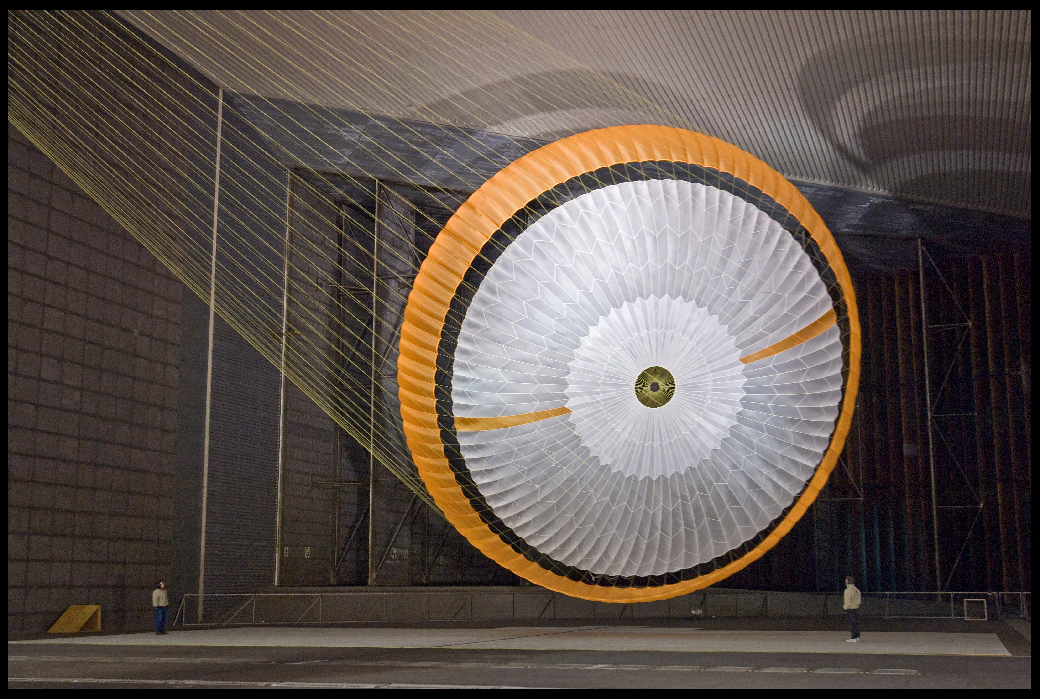
The parachute is the largest one of its kind ever constructed, coming in about 65 feet in diameter (you can see a scale here, courtesy JPL) The gap between the white and orange-hued sections prevented the chute from becoming torn during the descent phase.

You can also see a 3D view of the parachute on the ground here. The parachute’s suspension lines were made from Technora, with a fiber similar to Kevlar. The color is a creamy yellow, which is why they are not visible in the images such as those in the Phoenix lander descent image which were white.

Photo credit: NASA/JPL/University of Arizona

Note: This is a big story today. For more information, see PIA16813: MSL's Parachute Flapping in the Wind and Used Parachute on Mars Flaps in the Wind.

Thursday, February 7, 2013

Curiosity on Sol 157


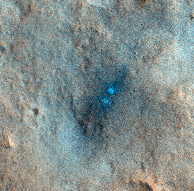
This HiRISE observation was performed in conjunction with a CRISM observation so that they could get good spectral data on the scour zone created by the MSL descent rockets.

Our higher resolution HiRISE image will allow the CRISM team to compare their data with ours. The scour zone is where MSL touched down. The pair of bright white spots in the HiRISE image show the area immediately below where sky crane's rockets were pointed. Those areas were "blasted clean" and therefore show brightest. The larger dark scour zone is dark because the fine dust has been blown away from the area leaving darker materials.

However, we also captured Curiosity on its 157th Sol as it was exploring Yellowknife Bay and about to drill its first rock.

This is the first time that we've captured the rover tracks in color, and they show up as a pair of dark lines moving across the landscape.

Note: the above image is non map-projected, so approximate north is down.

Photo credit: NASA/JPL/University of Arizona

Monday, January 21, 2013

Curiosity's Tracks in Gale Crater


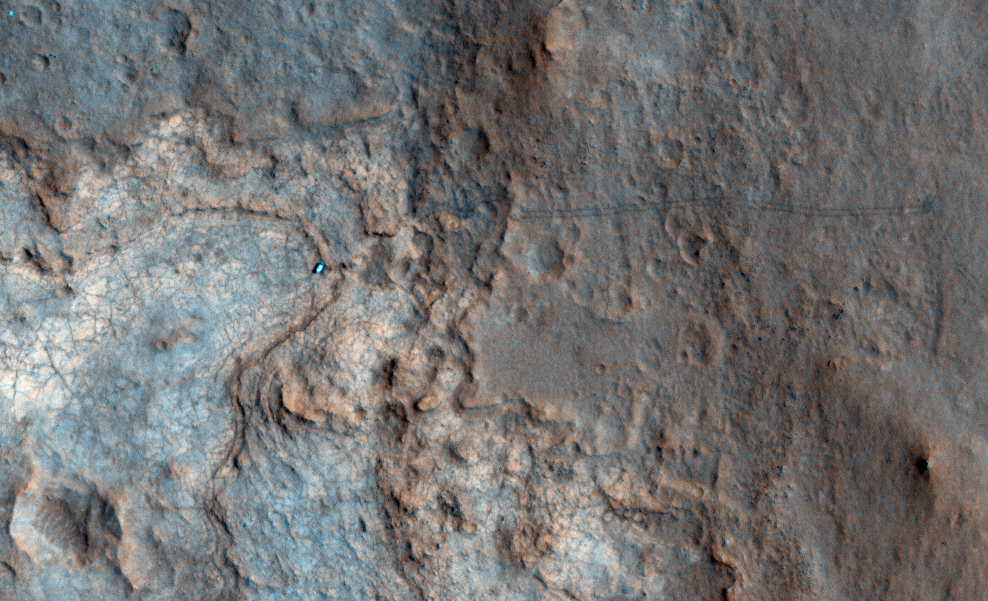
This image was acquired for color coverage of the region that the Curiosity rover may explore, but we acquired some extra RED (monochromatic) coverage of the rover tracks.

This image shows the entire distance traveled from the landing site (dark smudge at left) to its location as of 2 January 2013 (the rover is bright feature at right). The tracks are not seen where the rover has recently driven over the lighter-toned surface, which may be more indurated than the darker soil.

Photo credit: NASA/JPL/University of Arizona

Monday, September 10, 2012

3-D View from Bradbury Landing


This 3-D image from NASA's Curiosity was taken from the rover's Bradbury Landing site inside Gale Crater, Mars, using the left and right eyes of its Navigation camera. Between the rover on the right, and its shadow on the left, looms the rover's eventual target: Mount Sharp. The mountain's highest peak is not visible to the rover from the landing site.

This full-resolution, 360-degree stereo panorama was taken on sols 2 and 12 of the mission, or the 2nd and 12th Martian days since landing (Aug. 8 and 18, 2012). It requires viewing with the traditional red-blue 3-D glasses, with red going over the left eye.

Image credit: NASA/JPL-Caltech

Monday, August 13, 2012

Gale Crater Panorama


This is the first 360-degree panorama in color of the Gale Crater landing site taken by NASA's Curiosity rover. The panorama was made from thumbnail versions of images taken by the Mast Camera.

Scientists will be taking a closer look at several splotches in the foreground that appear gray. These areas show the effects of the descent stage's rocket engines blasting the ground. What appeared as a dark strip of dunes in previous, black-and-white pictures from Curiosity can also be seen along the top of this mosaic, but the color images also reveal additional shades of reddish brown around the dunes, likely indicating different textures or materials.

The images were taken late August 8 PDT (August 9 EDT) by the 34-millimeter Mast Camera. This panorama mosaic was made of 130 images of 144 by 144 pixels each. Selected full frames from this panorama, which are 1,200 by 1,200 pixels each, are expected to be transmitted to Earth later. The images in this panorama were brightened in the processing. Mars only receives half the sunlight Earth does and this image was taken in the late Martian afternoon.

Photo credit: NASA/JPL-Caltech/MSSS

Note: For more information, see NASA's Curiosity Beams Back a Color 360 of Gale Crater.

Wednesday, August 8, 2012

Curiosity Descending Into Gale Crater


NASA's Curiosity rover and its parachute were spotted by NASA's Mars Reconnaissance Orbiter as Curiosity descended to the surface on August 5 PDT (August 6 EDT). The High-Resolution Imaging Science Experiment (HiRISE) camera captured this image of Curiosity while the orbiter was listening to transmissions from the rover. Curiosity and its parachute are in the center of the white box; the inset image is a cutout of the rover stretched to avoid saturation. The rover is descending toward the etched plains just north of the sand dunes that fringe "Mt. Sharp." From the perspective of the orbiter, the parachute and Curiosity are flying at an angle relative to the surface, so the landing site does not appear directly below the rover.

The parachute appears fully inflated and performing perfectly. Details in the parachute, such as the band gap at the edges and the central hole, are clearly seen. The cords connecting the parachute to the back shell cannot be seen, although they were seen in the image of NASA's Phoenix lander descending, perhaps due to the difference in lighting angles. The bright spot on the back shell containing Curiosity might be a specular reflection off of a shiny area. Curiosity was released from the back shell sometime after this image was acquired.

This view is one product from an observation made by HiRISE targeted to the expected location of Curiosity about one minute prior to landing. It was captured in HiRISE CCD RED1, near the eastern edge of the swath width (there is a RED0 at the very edge). This means that the rover was a bit further east or downrange than predicted.

The image scale is 13.2 inches (33.6 centimeters) per pixel.

Photo credit: NASA/JPL-Caltech/Univ. of Arizona

Note: For more information, see NASA's Curiosity Rover Caught in the Act of Landing.

Tuesday, August 7, 2012

First Images from Curiosity


This image shows one of the first views from NASA's Curiosity rover, which landed on Mars the evening of August 5 PDT (early morning hours August 6 EDT). It was taken through a "fisheye" wide-angle lens on one of the rover's Hazard-Avoidance cameras. These engineering cameras are located at the rover's base. As planned, the early images are lower resolution. Larger color images are expected later in the week when the rover's mast, carrying high-resolution cameras, is deployed.

Photo credit: NASA/JPL-Caltech


This is one of the first images taken by NASA's Curiosity rover, which landed on Mars the evening of August 5 PDT (morning of August 6 EDT). It was taken through a "fisheye" wide-angle lens on the left "eye" of a stereo pair of Hazard-Avoidance cameras on the left-rear side of the rover. The image is one-half of full resolution. The clear dust cover that protected the camera during landing has been sprung open. Part of the spring that released the dust cover can be seen at the bottom right, near the rover's wheel.

On the top left, part of the rover's power supply is visible.

Some dust appears on the lens even with the dust cover off.

The cameras are looking directly into the sun, so the top of the image is saturated. Looking straight into the sun does not harm the cameras. The lines across the top are an artifact called "blooming" that occurs in the camera's detector because of the saturation.

As planned, the rover's early engineering images are lower resolution. Larger color images from other cameras are expected later in the week when the rover's mast, carrying high-resolution cameras, is deployed.

Photo credit: NASA/JPL-Caltech


Notes: For more information on the lower photo see NASA's New Mars Rover Sends Higher-Resolution Image. Are these blueberries in the sand?

Sunday, July 24, 2011

Daybreak at Gale Crater


This computer-generated view depicts part of Mars at the boundary between darkness and daylight, with an area including Gale Crater beginning to catch morning light.

Northward is to the left. Gale is the crater with a mound inside it near the center of the image. NASA has selected Gale as the landing site for the Mars Science Laboratory mission. The mission's rover will be placed on the ground in a northern portion of Gale crater in August 2012.

Gale crater is 96 miles (154 kilometers) in diameter and holds a layered mountain rising about 3 miles (5 kilometers) above the crater floor. The intended landing site is at 4.5 degrees south latitude, 137.4 degrees east longitude.

This view was created using three-dimensional information from the Mars Orbiter Laser Altimeter, which flew on NASA's Mars Global Surveyor orbiter. The vertical dimension is not exaggerated. Color information is based on general Mars color characteristics.

Image credit: NASA/JPL-Caltech