Pages

Showing posts with label Dawn. Show all posts

Wednesday, November 19, 2014

Geological Map of Vesta


This high-resolution geological map of Vesta is derived from Dawn spacecraft data. Brown colors represent the oldest, most heavily cratered surface. Purple colors in the north and light blue represent terrains modified by the Veneneia and Rheasilvia impacts, respectively. Light purples and dark blue colors below the equator represent the interior of the Rheasilvia and Veneneia basins. Greens and yellows represent relatively young landslides or other downhill movement and crater impact materials, respectively. This map unifies 15 individual quadrangle maps published this week in a special issue of Icarus. Map is a Mollweide projection, centered on 180 degrees longitude using the Dawn Claudia coordinate system.

Map credit: NASA/JPL-Caltech/ASU

Note: For more information, see PIA18789: Geological Time Scale of Vesta and Geologic Maps of Vesta from NASA's Dawn Mission Published.

Sunday, December 29, 2013

Sextilia Crater


This colorful image from NASA's Dawn mission shows material northwest of the crater Sextilia on the giant asteroid Vesta. Sextilia, located around 30 degrees south latitude, is at the bottom right of this image.

The image was taken by Dawn's framing camera from September to October 2011.

In this image, the entire color spectrum of Vesta becomes visible. While a large asteroid impact probably brought the black material, the red material may have been melted by the impact.

The composite image was created by assigning ratios of color information collected from several color filters in visible light and near-infrared light to maximize subtle differences in lithology (the physical characteristics of rock units, such as color, texture and composition). The color scheme pays special attention to the iron-rich mineral pyroxene.

Image credit: NASA/JPL-Caltech/UCLAMPS/DLR/IDA

Note: For more information, see Dawn Creates Guide to Vesta's Hidden Attractions.

Sunday, December 22, 2013

Antonia Crater


This colorized composite image from NASA's Dawn mission shows the crater Antonia, which lies in the enormous Rheasilvia basin in the southern hemisphere of the giant asteroid Vesta. The area lies around 58 degrees south latitude. Antonia has a diameter of 11 miles (17 kilometers).

The image was taken by Dawn's framing camera from September to October 2011.

The light blue material is fine-grain material excavated from the lower crust. The southern edge of the crater was buried by coarser material shortly after the crater formed. The dark blue of the southern crater rim is due to shadowing of the blocky material.

The composite image was created by assigning ratios of color information collected from several color filters in visible light and near-infrared light to maximize subtle differences in lithology (the physical characteristics of rock units, such as color, texture and composition). The color scheme pays special attention to the iron-rich mineral pyroxene.

Image credit: NASA/JPL-Caltech/UCLAMPS/DLR/IDA

Note: For more information, see Dawn Creates Guide to Vesta's Hidden Attractions.

Tuesday, December 17, 2013

Aelia Crater


This colorful composite image from NASA's Dawn mission shows the flow of material inside and outside a crater called Aelia on the giant asteroid Vesta. The area is around 14 degrees south latitude. The images that went into this composite were obtained by Dawn's framing camera from September to October 2011.

To the naked eye, these structures would not be seen. But here, they stand out in blue and red.

The crater has a diameter of 2.7 miles (4.3 kilometers). The exact origin of the flow structures is unknown. A possible explanation is that the impact that produced the crater could have created liquid material with different minerals than the surroundings.

The composite image was created by assigning ratios of color information collected from several color filters in visible light and near-infrared light to maximize subtle differences in lithology (the physical characteristics of rock units, such as color, texture and composition). The color scheme pays special attention to the iron-rich mineral pyroxene.

Image credit: NASA/JPL-Caltech/UCLAMPS/DLR/IDA

Note: For more information, see Dawn Creates Guide to Vesta's Hidden Attractions.

Wednesday, December 4, 2013

On the Way to Ceres


This artist's concept shows NASA's Dawn spacecraft heading toward the dwarf planet Ceres. Dawn spent nearly 14 months orbiting Vesta, the second most massive object in the main asteroid belt between Mars and Jupiter, from 2011 to 2012. It is heading towards Ceres, the largest member of the asteroid belt. When Dawn arrives, it will be the first spacecraft to go into orbit around two destinations in our solar system beyond Earth.

Illustration credit: NASA/JPL-Caltech

Note: For more information, see PIA17479: Closing in on Ceres, PIA17651: Journey to Ceres and NASA's Dawn Fills out its Ceres Dance Card.

Monday, November 11, 2013

Map of Rock Properties at Vesta


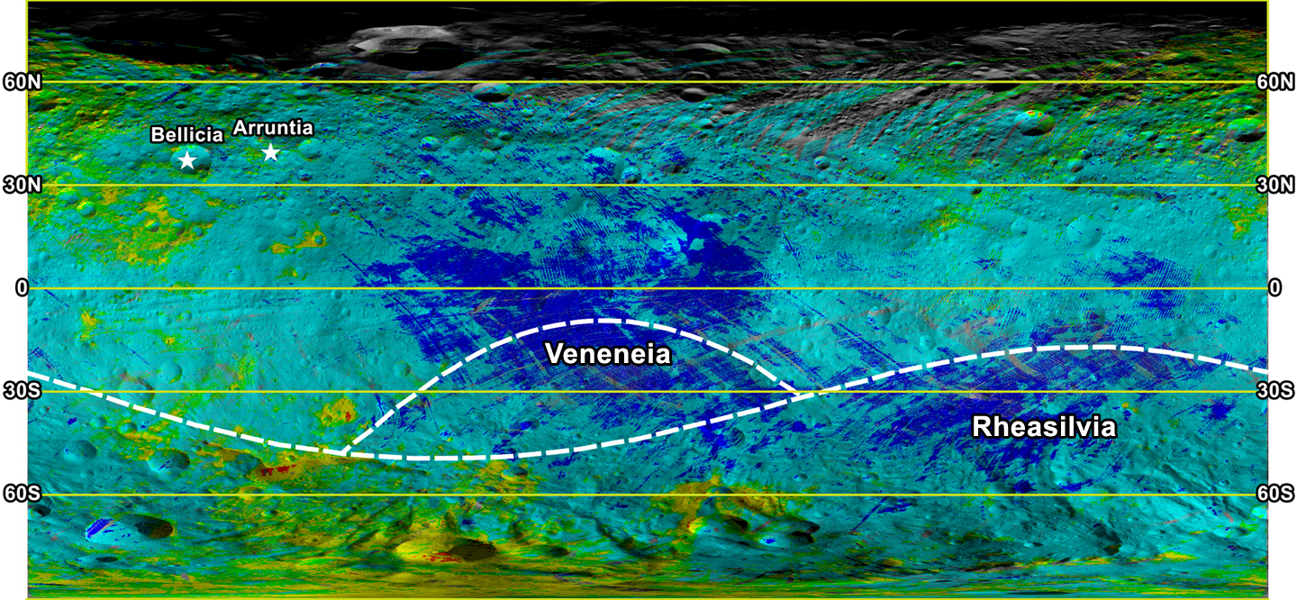
This colorized map from NASA's Dawn mission shows the types of rocks and minerals distributed around the surface of the giant asteroid Vesta. In this color scheme, red shows diogenite, a type of mineral thought to be formed through magmatic processes deep in the crust. Green shows howardite, a type of surface rock that is made of broken bits of different materials that are excavated, ejected and mixed by meteor impacts. These types of rocks are the most abundant observed on Vesta's surface. Blue shows eucrite, a type of rock formed in the crust of Vesta that isn't as deep down as diogenite. For example, Vesta's equatorial region is replete with eucrites. Yellow areas show regions with diogenite and howardite. The yellow and red areas have large quantities of the magnesium-and silicate-rich mineral diogenite, especially in the southern hemisphere. Cyan areas show regions with eucrite and howardite. Many howardite, eucrite and diogenite meteorites have been found on Earth, and earlier work from Dawn confirmed theories that they came from Vesta.

The location of two craters, Arruntia and Bellicia, are noted in the annotated version. At these craters, scientists unexpectedly found the mineral olivine. The outlines of the giant craters Rheasilvia and Veneneia are also noted. Scientists thought they'd find olivine in those locations but have not.

The data for this map were obtained by Dawn's visible and infrared mapping spectrometer (VIR) during Dawn's orbital measurements of Vesta from 2011 to 2012.


Image credit: NASA/JPL-Caltech/UCLA/ASI/INAF

Note: For more information, see PIA17476: Two Craters with Olivine, PIA17477: Contrast-Enhanced Image of Bellicia Crater, PIA17478: Bellicia Crater, in Visible Light, and It's Complicated: Dawn Spurs Rewrite of Vesta's Story.

Monday, September 30, 2013

Vesta, Before and After Dawn


These two images compare topographic maps of the giant asteroid Vesta as discerned by NASA's Hubble Space Telescope (top) and as seen by NASA's Dawn spacecraft (bottom). Hubble has been in an orbit around Earth, while Dawn orbited Vesta from 2011 to 2012. Although the absolute scale ranges are slightly different in Dawn data, Vesta's relative topography is remarkably consistent between the two data sets. The relative topography in Hubble data varies from 7.5 miles (12 kilometers) below to 7.5 miles (12 kilometers) above a reference ellipsoid shape of 180 by 174 by 142 miles (289 by 280 by 229 kilometers). The relative topography in Dawn data varies from 14 miles (22 kilometers) below to 12 miles (19 kilometers) above a reference ellipsoid shape of 177 by 177 by 142 miles (285 by 285 by 229 kilometers).


These two maps of the giant asteroid Vesta show patterns of brightness from NASA's Hubble Space Telescope (top) and NASA's Dawn spacecraft (bottom). Hubble's view is from an orbit around Earth. Dawn went into orbit around Vesta from 2011 to 2012. Scientists have been able to correlate several bright and dark features originally identified in Hubble images with features imaged at high resolution by the Dawn spacecraft's framing camera.

Image credits: (top) NASA/ESA/Cornell and NASA/JPL-Caltech/UCLA/MPS/DLR/IDA; (bottom) NASA/ESA/PSI/MIT and NASA/JPL-Caltech/UCLA/MPS/DLR/IDA

Note: For more information, see PIA17467: Asteroid or Mini-Planet? Hubble Maps the Ancient Surface of Vesta, Take a Virtual Tour of Vesta With New High-Resolution Images and Dawn Reality-Checks Telescope Studies of Asteroids.

Wednesday, May 15, 2013

NASA Scientists Find Moon, Asteroids Share History


Scientists have now discovered that studying meteorites from the giant asteroid Vesta helps them understand the event known as the "lunar cataclysm," when a repositioning of the gas giant planets destabilized a portion of the asteroid belt and triggered a solar-system-wide bombardment.

NASA and international researchers have discovered that Earth's moon has more in common than previously thought with large asteroids roaming our solar system.

Scientists from NASA's Lunar Science Institute (NLSI) in Moffett Field, California, discovered that the same population of high-speed projectiles that impacted our lunar neighbor four billion years ago, also hit the giant asteroid Vesta and perhaps other large asteroids.

The research unveils an unexpected link between Vesta and the moon, and provides new means for studying the early bombardment history of terrestrial planets. The findings are published in the March issue of Nature Geoscience.

"It's always intriguing when interdisciplinary research changes the way we understand the history of our solar system," said Yvonne Pendleton, NLSI director. "Although the moon is located far from Vesta, which is in the main asteroid belt between the orbits of Mars and Jupiter, they seem to share some of the same bombardment history."

The findings support the theory that the repositioning of gas giant planets like Jupiter and Saturn from their original orbits to their current location destabilized portions of the asteroid belt and triggered a solar system-wide bombardment of asteroids billions of years ago, called the lunar cataclysm.

The research provides new constraints on the start and duration of the lunar cataclysm, and demonstrates that the cataclysm was an event that affected not only the inner solar system planets, but the asteroid belt as well.

The moon rocks brought back by NASA Apollo astronauts have long been used to study the bombardment history of the moon. Now the ages derived from meteorite samples have been used to study the collisional history of main belt asteroids. In particular, howardite and eucrite meteorites, which are common species found on Earth, have been used to study asteroid Vesta, their parent body. With the aid of computer simulations, researchers determined that meteorites from Vesta recorded high-speed impacts which are now long gone.

Researchers have linked these two datasets and found that the same population of projectiles responsible for making craters and basins on the moon were also hitting Vesta at very high velocities, enough to leave behind a number of telltale, impact-related ages.

The team's interpretation of the howardites and eucrites was augmented by recent close-in observations of Vesta's surface by NASA's Dawn spacecraft. In addition, the team used the latest dynamical models of early main belt evolution to discover the likely source of these high velocity impactors. The team determined that the population of projectiles that hit Vesta had orbits that also enabled some objects to strike the moon at high speeds.

"It appears that the asteroidal meteorites show signs of the asteroid belt losing a lot of mass four billion years ago, with the escaped mass beating up on both the surviving main belt asteroids and the moon at high speeds" says lead author Simone Marchi, who has a joint appointment between two of NASA's Lunar Science Institutes, one at the Southwest Research Institute in Boulder, Colorado, and another at the Lunar and Planetary Institute in Houston. "Our research not only supports the current theory, but it takes it to the next level of understanding."

Image credit: NASA/GSFC/ASU/JPL-Caltech/UCLA/MPS/DLR/IDA

Monday, January 28, 2013

Dark Materials in Vesta's Southern Hemisphere


This map shows the distribution of dark materials throughout the southern hemisphere of the giant asteroid Vesta. The circles, diamonds, and stars show where the dark material appears in craters, spots and topographic highs. The dashed line depicts the rim of the Veneneia basin, the black line the rim of the younger Rheasilvia basin.

The red and white indicate high topography and blue and violet indicate low topography.

Image credit: NASA/JPL-Caltech/UCLA/MPS/DLR/IDA

Note: For more information, see Picture This: Vesta's Dark Materials in Dawn's View.

Thursday, September 13, 2012

Full Topographical Maps of Vesta


This image from NASA's Dawn mission shows the topography of the northern and southern hemispheres of the giant asteroid Vesta, updated with pictures obtained during Dawn's last look back. Around the time of Dawn's departure from Vesta in the late summer of 2012, dawn was beginning to creep over the high northern latitudes, which were dark when Dawn arrived in the summer of 2011.

These color-shaded relief maps show the northern and southern hemispheres of Vesta, derived from images analysis. Colors represent distance relative to Vesta's center, with lows in violet and highs in red. In the northern hemisphere map on the left (Figure 1), the surface ranges from lows of minus 13.82 miles (22.24 kilometers) to highs of 27.48 miles (44.22 kilometers). Light reflected off the walls of some shadowed craters at the north pole (in the center of the image) was used to determine the height. In the southern hemisphere map on the right (Figure 2), the surface ranges from lows of minus 23.65 miles (38.06 kilometers) to 26.61 miles (42.82 kilometers).

The shape model was constructed using images from Dawn's framing camera that were obtained from July 17, 2011, to August 26, 2012. The data have been stereographically projected on a 300-mile-diameter (500-kilometer-diameter) sphere with the poles at the center.

The three craters that make up Dawn's "snowman" feature can be seen at the top of the northern hemisphere map on the left. A mountain more than twice the height of Mount Everest, inside the largest impact basin on Vesta, can be seen near the center of the southern hemisphere map on the right.

These images are the last in Dawn's Image of the Day series during the cruise to Dawn's second destination, Ceres. A full set of Dawn data is being archived at http://pds.nasa.gov/.

Image credit: NASA/JPL-Caltech/UCAL/MPS/DLR/IDA/PSI

Note: For more information, see Vesta in Dawn's Rear View Mirror.

Wednesday, June 13, 2012

Vesta's Coat of Many Colors


This animation of Vesta is made from images taken with Dawn's framing camera. Many of the images were taken at different viewing angles to provide stereo for use in determining the topography. Other images were taken through special infrared and visible light filters in the camera. These infrared and visible light images have been combined and represented in colors that highlight the nature of the minerals on Vesta's surface. Green shows the amount of iron. Scientists have not yet determined the composition indicated by the other colors.

The animation begins overlooking Vesta's north pole and gradually moves southward. The northern polar region is shown as gray because the sun has not yet illuminated this part of Vesta's surface during Dawn's exploration of the asteroid.

It is clear from the wide range of colors that Vesta is very diverse; it is one of the most diversely colored asteroids that has been imaged. The northern troughs can be seen running obliquely from the northern shadows to the Vestan equator. The "snowman" craters Marcia, Calpurnia and Minucia are also clearly visible just north of the equator. Next, the band of equatorial troughs comes into view and Vesta's heavily cratered surface is also displayed. A number of areas of ejecta show a strong red-orange color. As the viewing angle moves towards the southern pole, the large central complex protrudes from the giant Rheasilvia impact basin. The rim and some of the internal structure of the Rheasilvia impact basin are also clearly visible. The Rheasilvia impact basin has a strong greenish appearance here, which signifies a region abundant in iron.

Dawn obtained the images used to make this animation in September and October 2011. The distance to the surface of Vesta is around 420 miles (680 kilometers) on average and the images have an average resolution of about 210 feet (65 meters) per pixel. The color composite mosaic was prepared by the German Aerospace Center. The animation and the topographic model were made by the Planetary Science Institute, Tucson, Arizona.

Video credit: NASA/JPL-Caltech/UCLA/MPS/DLR/IDA/PSI

Note: If the above video doesn't work properly, click here.

Sunday, May 13, 2012

Vesta's Snowman Craters in Color


Three impact craters of different sizes, arranged in the shape of a snowman, make up one of the most striking features on Vesta, as seen in this view from NASA's Dawn mission. In this view the three "snowballs" are upside down, so that the shadows make the features easily recognizable. North is to the lower right in the image, which has a resolution of 230 feet (70 meters) per pixel.

The image is composed of many individual photographs taken between October and December 2011 by Dawn's framing camera. They were obtained during the high-altitude mapping orbit, at about 420 miles (680 kilometers) above Vesta's surface.

The largest of the three craters, Marcia, has a diameter of about 40 miles (60 kilometers). The central crater, which is about 30 miles (50 kilometers) in diameter, is named Calpurnia, and the lower crater, named Minucia, has a diameter of about 14 miles (22 kilometers). Marcia and Calpurnia are possibly the result of an impact by doublet asteroids, whereas Minucia was formed by a later impact.

To derive the color information, scientists combined images acquired by the framing camera in two near-infrared channels (0.917 microns and 0.749 microns) and an ultraviolet channel (0.438 microns). The true colors of the surface of Vesta differ somewhat from what is displayed here, but this mode of reproduction allows subtle changes in material properties across the craters and material ejected from impacts to be detected. In both Marcia and Calpurnia, landslides can be seen; also, dark material has been exposed below the rim of Marcia.

Photo credit: NASA/JPL-Caltech/UCLA/MPS/DLR/IDA

Monday, April 30, 2012

Vesta Topography and Gravity Maps


This set of images from NASA's Dawn mission shows topography of the southern hemisphere of the giant asteroid Vesta and a map of Vesta's gravity variations that have been adjusted to account for Vesta's shape. The shaded relief map on the left shows the outlines of the two ancient basins, Rheasilvia and Veneneia. On the right is a map of the residual gravity field created by removing the gravity due to the hills and valleys within the crustal layer, revealing the signature of variations in density.

Red shows the strongest gravitational pull in this scheme, measured in milligal units, and dark blue shows the weakest. Milligals are a unit of acceleration due to gravity. The large central peak of the Rheasilvia basin, which appears as the yellow area just above and to the left of center, has a small positive residual gravity anomaly. This indicates the crust there is denser, coming from deeper within the body, or perhaps is less fractured. The gravity lows near the basin rim on the right, shown in dark blue, likely indicate rock that is lighter as a result of being pulverized by the two impacts.

The topography model is derived from framing camera images from Dawn's high-altitude mapping orbit (420 miles or 680 kilometers above the surface) and the gravity data come from the low-altitude mapping orbit (130 miles or 210 kilometers above the surface).


This video from NASA's Dawn mission shows that the gravity field of Vesta closely matches the surface topography of the giant asteroid Vesta. The video shows shaded topography from Dawn's framing camera on the left, with troughs and craters visible, and color-contoured data from Dawn's gravity experiment on the right. Red shows the areas with a higher than average gravity field and blue-purple shows the areas where the field is weaker on average. The highest topography, on the rim of the Rheasilvia basin deep in the southern hemisphere, shows a particularly strong gravity field. The dashed line indicates the north-south axis.

The topography model is derived from framing camera images from Dawn's high-altitude mapping orbit (420 miles or 680 kilometers above the surface), and the gravity data come from the low-altitude mapping orbit (130 miles or 210 kilometers above the surface).

Vesta takes approximately 5.34 hours to make a rotation.

Map credit: NASA/JPL-Caltech/UCLA/MPS/DLR/IDA; video credit: NASA/JPL-Caltech/UCLA/MPS/DLR/IDA

Friday, March 30, 2012

Bright Rays from Canuleia Crater


In this image from NASA's Dawn spacecraft, bright material extends out from the crater Canuleia on Vesta. The bright material appears to have been thrown out of the crater during the impact that created it.

Canuleia crater is located outside the rim of the Rheasilvia basin in the southern hemisphere, inside the quadrangle named for Urbinia crater. It is about 6 miles (10 kilometers) in diameter. The bright ejected material extends 12 to 19 miles (20 to 30 kilometers) beyond the crater's rim.

This image was obtained by Dawn's framing camera on October 25, 2011, during high-altitude mapping orbit (on average 420 miles or 680 kilometers above the surface). This particular image was obtained at an altitude of 435 miles (700 kilometers). It covers about 2,000 square miles (5,000 square kilometers).

Photo credit: NASA/JPL-Caltech/UCLA/MPS/DLR/IDA/UMD

Note: This is only one of fifteen images recently released about features on Vesta. Choosing just one image to highlight on this blog was rather difficult. Be sure to visit the JPL website to view the other fourteen images!

Sunday, January 29, 2012

Mercury and Vesta


In March 2011, MESSENGER became the first spacecraft to orbit the planet Mercury. In July of the same year, the Dawn spacecraft became the first to orbit a main-belt asteroid, Vesta. Both MESSENGER and Dawn are missions in the Discovery program, NASA's lowest-cost category of planetary mission.

The image above shows Mercury on the left, and Vesta on the right. Both surfaces are marked by impact craters, but the most immediately noticeable difference is that Vesta has a much more irregular shape. This is a consequence of Mercury's far larger gravity, which has squeezed the planet into a sphere. Vesta's weak gravity is less able to overcome the strength of the rocks. Mercury's mass is about 1300 times greater than that of Vesta.

MESSENGER image of planet Mercury (left)
Date acquired:
September 29, 2009
Image Mission Elapsed Time (MET): 162741055
Instrument: Wide Angle Camera (WAC) of the Mercury Dual Imaging System (MDIS)
WAC filter: 7 (748 nanometers)
Scale: Mercury's diameter is 4880 km (3030 mi.)

Dawn image of asteroid Vesta (right)
Date acquired:
July 18, 2011
Instrument: Dawn Framing Camera, clear filter
Scale: Vesta's diameter is about 530 km (329 mi.)

Photo credits: NASA/Johns Hopkins University Applied Physics Laboratory/Carnegie Institution of Washington
Dawn Vesta image credit: NASA/JPL-Caltech/UCLA/MPS/DLR/IDA

Friday, December 23, 2011

Closer and Closer to the Vesta Surface


NASA's Dawn spacecraft has spiraled closer and closer to the surface of the giant asteroid Vesta. These images were obtained by Dawn's framing camera in the three phases of its campaign since arriving at Vesta in mid-2011.

The two images on the left represent an identical area, first observed during Dawn's survey orbit (far left image). That orbit aimed to obtain a global characterization of the asteroid. The picture in the center is from Dawn's high-altitude mapping orbit (HAMO) when the surface was systematically imaged during September and October 2011 from an altitude of about 430 miles (700 kilometers) with about 230 feet (70 meters-per-pixel) resolution for global high-resolution stereo image data that were used to develop a global shape model and topographic maps.

Since December 12, 2011, the orbiter has been circling Vesta in a slightly elliptical orbit known as low-altitude mapping orbit (LAMO) at an average 130 miles (210 kilometers) above the asteroid's surface. The image on the right was obtained on December 13 from an altitude of 124 miles (199 kilometers) to the surface and has a resolution of 75 feet (23 meters) per pixel. It covers an area about 12 miles by 12 miles (19 kilometers by 19 kilometers).

The low altitude image has a resolution more than three times better than the resolution from the HAMO phase. There is a lot more detail in the image, like small impact craters or slumping at the steep-flanked mountain in the image center that can be identified in the two images to the left. The center of the LAMO image is at about 45.5 degrees south latitude and 325.1 degrees east longitude.

Photo credit: NASA/JPL-Caltech/UCLA/MPS/DLR/IDA

Saturday, December 10, 2011

Is Vesta the "Smallest Terrestrial Planet?"


NASA's Dawn spacecraft spent the last four years voyaging to asteroid Vesta – and may have found a planet.

Vesta was discovered over two hundred years ago but, until Dawn, has been seen only as an indistinct blur and considered little more than a large, rocky body. Now the spacecraft's instruments are revealing the true complexity of this ancient world.

"We're seeing enormous mountains, valleys, hills, cliffs, troughs, ridges, craters of all sizes, and plains," says Chris Russell, Dawn principal investigator from UCLA. "Vesta is not a simple ball of rock. This is a world with a rich geochemical history. It has quite a story to tell!"

In fact, the asteroid is so complex that Russell and members of his team are calling it the "smallest terrestrial planet."

Vesta has an iron core, notes Russell, and its surface features indicate that the asteroid is "differentiated" like the terrestrial planets Earth, Mercury, Mars, and Venus.

Differentiation is what happens when the interior of an active planet gets hot enough to melt, separating its materials into layers. The light material floats to the top while the heavy elements, such as iron and nickel, sink to the center of the planet.

Researchers believe this process also happened to Vesta.

The story begins about 4.57 billion years ago, when the planets of the Solar System started forming from the primordial solar nebula. As Jupiter gathered itself together, its powerful gravity stirred up the material in the asteroid belt so objects there could no longer coalesce. Vesta was in the process of growing into a full-fledged planet when Jupiter interrupted the process.

Although Vesta’s growth was stunted, it is still differentiated like a true planet.

"We believe that the Solar System received an extra slug of radioactive aluminum and iron from a nearby supernova explosion at the time Vesta was forming," explains Russell. "These materials decay and give off heat. As the asteroid was gathering material up into a big ball of rock, it was also trapping the heat inside itself."

As Vesta’s core melted, lighter materials rose to the surface, forming volcanoes and mountains and lava flows.

"We think Vesta had volcanoes and flowing lava at one time, although we've not yet found any ancient volcanoes there," says Russell. "We're still looking. Vesta's plains seem similar to Hawaii's surface, which is basaltic lava solidified after flowing onto the surface.

Vesta has so much in common with the terrestrial planets, should it be formally reclassified from "asteroid" to "dwarf planet"?

"That's up to the International Astronomical Union, but at least on the inside, Vesta is doing all the things a planet does."

If anyone asks Russell, he knows how he would vote.

Text credit: NASA; video credit: NASA

Monday, November 21, 2011

Vesta's Domitia Crater


These Dawn FC (framing camera) images show the Domitia crater in Vesta's northern hemisphere and the topography of the surrounding region, which includes the "Snowman" craters. Domitia crater is the roughly 50km diameter crater in the top of the image, slightly offset from the center of the image. It is a highly degraded crater and its rim is nearly totally obscured by smaller, younger impact craters. Domitia crater is both large and distinctive so its name is used to name the quadrangle in which it is located. The left image is an albedo image, which is taken directly through the clear filter of the FC. Such an image shows the albedo (e.g. brightness/darkness) of the surface. The right image uses the same albedo image as its base but then a color-coded height representation of the topography is overlain onto it. The topography is calculated from a set of images that were observed from different viewing directions, called stereo images. The various colors correspond to the height of the area that they color. For example, the white area in the bottom right of the image is the highest area and the dark blue top edge of the image is the lowest area. The bottom edge of Domitia crater is located on the boundary between the dark and light blue so it defines a sharp topography/height boundary.

This image is in Vesta's Domitia, Marcia and Numisia quadrangles and the center latitude and longitude of the image is 22.3°N, 198.7°E. NASA's Dawn spacecraft obtained this image with its framing camera on August 29th 2011. This image was taken through the camera's clear filter. The distance to the surface of Vesta is 2740 km and the image has a resolution of about 250 meters per pixel. This image was acquired during the Survey phase of the mission.

Photo credit: NASA/JPL-Caltech/UCLA/MPS/DLR/IDA

Thursday, November 3, 2011

Vesta Crater and Ejecta in Visible and Infrared Wavelengths


Above are three different composite images of the same region of Vesta's surface. These images were produced by combining images obtained by the Visible and Infrared Imaging Spectrometer (VIR) instrument aboard NASA's Dawn spacecraft. The VIR instrument can image Vesta in many different wavelength regions, called bands, in the near ultraviolet, visible and infrared parts of the electromagnetic spectrum, which corresponds to a wavelength range of 300nm to 5000nm. The top image is a RGB composite simulated true color image where red is set as the 700nm band, green is set as the 550nm band and blue is set as the 440nm band. The wavelength of red light is around 700nm, of green light is around 550nm and of blue light is around 440nm, so this image approximates what the human eye would see looking at Vesta. The middle image is taken in the infrared part of the spectrum and shows the thermal emission of Vesta's surface; the light colors correspond to the hottest temperatures and the dark colors correspond to the coldest temperatures. The bottom image is another RGB composite image in which bands from the visible and infrared were combined to enhance the differences in the composition of Vesta's surface. In the case of this bottom image different colors correspond to characteristics of the composition of the surface. Different compositions can help to identify regions which have undergone different geological processes. For example, in the bottom image the green ejecta blanket of the crater on the right is very distinctive against the blue and red surface of the rest of Vesta. This ejecta blanket is much harder to identify in the other images.

Photo credit: NASA/JPL-Caltech/UCLA/ASI/INAF/IASF/IFSI

Friday, October 28, 2011

Color Composite Images of Vesta


These Dawn FC (framing camera) composite images show the spectacular spectral diversity of Vesta's surface. The FC has 7 color filters which allow it to image Vesta in a number of different wavelengths of light. Being able to image in many wavelengths enhances features and colors that would otherwise be indistinguishable to the human eye. The left image shows a RGB color composite image of Vesta. RGB stands for red, green and blue and in this case red is the 750nm filter, green is the 920nm filter and blue is the 980nm filter. Nm stands for nanometers and is a measure of the wavelength of light. The images from these 3 filters were combined into this one RGB composite image, which enhances Vesta's coloration. The right image is also a RGB composite image. This time red is the ratio of the brightness at a wavelength of 750nm to the brightness at 440nm; green is used for the ratio of the brightness at 750nm to 920nm and blue is used for the ratio of the brightness at 440nm to 750nm. These ratios have all been picked for specific scientific purposes. The green shows the relative strength of a particular mineralogical characteristic, the ferrous absorption band, at 1000nm so that a brighter green color signifies a higher relative strength of this band. The blending between the red and blue heightens the color range of visible light.

Photo credit: NASA/JPL-Caltech/UCLA/MPS/DLR/IDA