Pages

Showing posts with label Lunar Exploration. Show all posts

Monday, March 12, 2012

Gumdrop Meets Spider


This image, taken on March 6, 1969, shows the Apollo 9 Command and Service Modules docked with the Lunar Module. Apollo 9 astronaut Dave Scott stands in the open hatch of the Command Module, nicknamed "Gumdrop," docked to the Lunar Module "Spider" in Earth orbit. His crewmate Rusty Schweickart, lunar module pilot, took this photograph from the porch of the lunar module. Inside the lunar module was Apollo 9 commander Jim McDivitt. The crew tested the orbital rendezvous and docking procedures that made the lunar landings possible.

Photo credit: NASA

Note: This photo has been one of the Minister's favorites since his childhood; for some reason, this photo has a strong emotional appeal to him. Perhaps it's the red spacehelmet. More astronauts should wear red spacehelmets.

Saturday, December 18, 2010

Lunar South Pole Illumination Map


Multi-temporal illumination map of the lunar south pole, Shackleton Crater (19 km diameter) is in the center, the south pole is located approximately at 9 o'clock on its rim. Mapped area extends from 88°S to 90°S.

The spin axis of the Moon is tilted by only 1.54° (compared to Earth's 23.5°), leaving some areas near the poles in permanent shadow while other nearby regions remain sunlit for the majority of the year. One of the primary objectives of LROC is to unambiguously identify these regions.

In a six month (six lunar days) period, the LROC Wide Angle Camera (WAC) collected 1,700 images of the South Pole covering the same area. Each image was map projected and converted to a binary image (if the ground was illuminated that pixel was set to one, and if shadowed zero) to differentiate between sunlit and shadowed regions. All the binary images were then stacked, and then for each pixel it was determined what percentage of the time during six months that spot was illuminated. Presto - an illumination map! The LROC team is making daily (which is about 28 Earth days) and yearly illumination maps for both poles. Such maps will provide the foundation for planning future robotic and human missions to the poles.

Photo credit: NASA/GSFC/Arizona State University

Tuesday, August 17, 2010

A Path Not Taken


Mare surface in Sinus Aestuum near a lunar exploration site proposed in the late 1950s. Image width is 460 m.

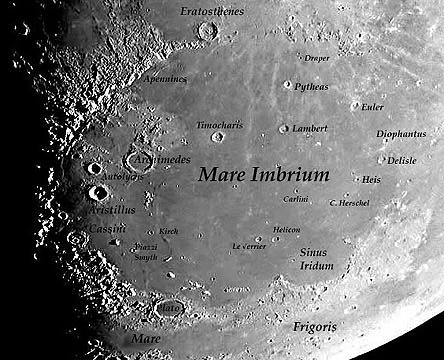
Thinking about locations on the Moon where humans should be exploring is nothing new. In the late 1950s, at the dawn of the Space Age (when Project Mercury was still getting off the ground), the United States Army proposed to establish a large lunar base to use for a variety of science, engineering, and military tasks. Despite the paucity of data about the lunar surface at that point in history, the Army team that proposed Project Horizon suggested several notional sites for this lunar outpost based on what was known at the time. One of these sites was located near this region in Sinus Aestuum, located southeast of Eratosthenes Crater just beyond the southern rim of the of the great Imbrium basin.

We know more about the Moon now than we did when this location was proposed over five decades ago. Knowing what we do now, it turns out that this would have been a fantastic location for an early lunar outpost. As you can see in the image above, this mare surface is relatively smooth, the near-equatorial location would have made for a dynamically favorable landing target, and the nearside location would enable continuous real-time communications with Earth. The location would have permitted sampling (and age-dating) the rays of Copernicus and direct exploration of Eratosthenes Crater, the foundations for the lunar stratigraphic time scale. This location is centrally located between several targets now known to have high scientific and exploration interest, including the aforementioned Eratosthenes Crater, Copernicus Crater, the rich ores of the Rima Bode regional dark mantling deposit, the Sinus Aestuum regional dark mantling deposit, and the southern rim of the Imbrium Basin, although an extended surface traverse would have been required to access those locations from this site. Future robotic and human lunar sortie missions will provide important new scientific insights into the lunar surface, but long-duration human lunar outposts will provide even more valuable benefits, including the flexibility to make exploration forays that last longer (or even repeat visits) to key scientific locations, as well as providing more infrastructure to leverage existing lunar resources.


LROC Wide Angle Camera [WAC] monochrome mosaic of the Sinus Aestuum region. Approximate location of the above image is shown by the small white arrow. Black rectangles are regions between individual WAC images that will be filled at a later date.

Photo credit: NASA/GSFC/Arizona State University