Backdropped by the blackness of space, the International Space Station is seen from Space Shuttle Atlantis as the two spacecraft begin their relative separation. Earlier the STS-122 and Expedition 16 crews concluded almost nine days of cooperative work onboard the shuttle and station. Undocking of the two spacecraft occurred at 3:24 a.m. (CST) on Feb. 18, 2008.
Wednesday, February 20, 2008
The International Space Station by Atlantis (STS-122)
Credit: ESA/NASA
Wednesday, February 13, 2008
Columbus Laboratory, by STS-122
Credit: NASA
As of the time of this writing, STS-122, on board the Space Shuttle Atlantis, is five and one-half days into a planned 12-day mission. The primary objective for STS-122 is to install the ESA's Columbus Laboratory on to the International Space Station, which, the Minister, is happy to report, has been a success so far to date. One of the other objectives for this flight is that Flight Engineer Daniel M. Tani of Expedition 16 will be returning home to Earth, with his place being taken by Léopold Eyharts, of France. Atlantis is currently scheduled to return to Earth next Tuesday, February 19th.
In the above image, the Columbus Laboratory sits in Atlantis' payload bay (the large grey object with the "ESA" sign). Also visible are the vertical stabilizer, the orbital maneuvering system (OMS) pods and, of course, the Earth. This photo was taken on February 8th, the second day of the flight, by an STS-122 crewmember.
Tuesday, February 12, 2008
The Sun, by SOHO
Credit: SOHO (ESA & NASA)
A number of spacecraft observe our Sun. One mission, which has been in operation for almost a dozen years now, is the Solar & Heliospheric Observatory (SOHO). Launched on December 2, 1995 and beginning operations in May 1996, SOHO is a joint collaboration between the European Space Agency and NASA to study the Sun from the core to the outer corona and the solar wind. SOHO is also the primary provider for near-real time data of the Sun's activities, which allows astronomers to forecast space weather.
One of the instruments aboard SOHO is the Extreme Ultraviolet Imaging Telescope or EIT. The EIT studies the lower corona and the transition region between the chromosphere and the corona by taking full disc images of the Sun at four selected wavelengths in the extreme ultraviolet. These wavelengths correspond to temperatures between 80,000 and 2,500,000°C.
The above image is a composite of three separate images, taken in May 1998, at 171Å (Angstrom; the blue image), 195Å (green) and 284Å (yellow). Each wavelength reveals solar features unique to that wavelength. Since the EIT images come from the spacecraft in black and white, they are color coded for easy identification.
Sunday, February 10, 2008
Neptune, by Voyager 2
Credit: NASA
While Neptune may be the farthest of the eight planets orbiting the Sun (as defined by the International Astronomical Union (IAU)), it certainly doesn't lack for interesting features. While Uranus' atmosphere is primarily a mix of hydrogen, helium and methane (the last giving the planet its light blue hue), Neptune's atmosphere is primarily made up of methane, which is what gives the planet its deep blue color. Neptune is the smallest of the four gas giants, but it's also the densest of that set.
Although Neptune receives only 3% as much sunlight as Jupiter, it showed several large dark spots reminiscent of Jupiter's hurricane-like storms. The largest spot is named the "Great Dark Spot" and is an anticyclone similar to Jupiter's Great Red Spot. Neptune's Great Dark Spot is comparable in size, relative to the planet, and at the same latitude (22° South latitude) as Jupiter's Great Red Spot. However, Neptune's Great Dark Spot is far more variable in size and shape than the Great Red Spot. Another spot, named "D2" by the Voyager 2 scientists, is located far to the south of the Great Dark Spot, at 55° South latitude. It is almond-shaped, with a bright central core, and moves eastward around the planet in about 16 hours.
Most of the winds on Neptune blow in a westward direction, which is retrograde, or opposite to the rotation of the planet. Near the Great Dark Spot, there are retrograde winds blowing up to 1,500 miles an hour (2,400 kph) -- the strongest winds measured on any planet, including windy Saturn.
The only spacecraft to date to fly past Neptune was Voyager 2, which hurtled past Neptune's north pole on August 25, 1989. Voyager 2's closest approach was a mere 4,950 km from the planet, the closest approach Voyager 2 made of any planet. The fly-by of Neptune put Voyager 2 on a course 48° south of the ecliptic plane of the solar system, roughly toward the constellation Canis Major and the star Sirius, with a rate of speed about 470 million km per year.
Friday, February 8, 2008
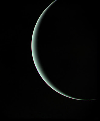
Uranus, by Voyager 2
Credit: NASA
The fly-by of Voyager 2 past the planet Uranus should have been one of excitement and wonder as it had been in July 1979 and August/September 1981, when Voyager passed by the planets Jupiter and Saturn, respectively. However, four days after Voyager's closest approach to Uranus, the Space Shuttle Challenger was destroyed and the new discoveries from the outer solar system were quickly ignored in the wake of the tragedy.
This photo was taken by Voyager 2 on January 25, 1986, the day after the closest approach, at a distance of 600,000 miles (about 965,000 km). Voyager 2 is still operational, over 40 years after its launch, and is over 85.039 Astronomical Units (AU) or 7.9 billion miles (12.7 billion km) away from the Sun at this time.
Tuesday, February 5, 2008
Saturn, by Cassini
Credit: NASA/JPL/Space Science Institute
This natural color mosaic was acquired by the Cassini spacecraft as it soared 39 degrees above the unilluminated side of Saturn's rings.
Little light makes its way through the rings to be scattered in Cassini's direction in this viewing geometry, making the rings appear somewhat dark compared to the reflective planet. The view can be contrasted with earlier mosaics designed to showcase the rings rather than the planet, which were therefore given longer exposure times (see Blinding Saturn and Ring World).
Bright clouds play in the blue-gray skies of the north. The ring shadows continue to caress the planet as they slide farther south toward their momentary disappearance during equinox in 2009. The rings' reflected light illuminates the southern hemisphere on Saturn's night side.
The scene is reminiscent of the parting glance of NASA's Voyager 1 as it said goodbye to Saturn in 1981 (see PIA00335). Cassini, however, will continue to orbit Saturn for many years to come.
Three of Saturn's moons are visible in this image: Mimas (397 kilometers, or 247 miles across) at the 2 o'clock position, Janus (181 kilometers, or 113 miles across) at the 4 o'clock position and Pandora (84 kilometers, or 52 miles across) at the 8 o'clock position. Pandora is a faint speck just outside the narrow F ring.
...
The view combines 45 images -- 15 separate sets of red, green and blue images -- taken over the course of about two hours, as Cassini scanned across the entire main ring system.
The images in this view were obtained on May 9, 2007, at a distance of approximately 1.1 million kilometers (700,000 miles) from Saturn. Image scale is about 62 kilometers (39 miles) per pixel.
Monday, February 4, 2008
Jupiter and Io, by New Horizons
Credit: NASA/Johns Hopkins University Applied Physics Laboratory/Southwest Research Institute
This is a montage of New Horizons images of Jupiter and its volcanic moon Io, taken during the spacecraft’s Jupiter flyby [pdf] in early 2007. The Jupiter image is an infrared color composite taken by the spacecraft’s near-infrared imaging spectrometer, the Linear Etalon Imaging Spectral Array (LEISA) at 1:40 UT on Feb. 28, 2007. The infrared wavelengths used (red: 1.59 µm, green: 1.94 µm, blue: 1.85 µm) highlight variations in the altitude of the Jovian cloud tops, with blue denoting high-altitude clouds and hazes, and red indicating deeper clouds. The prominent bluish-white oval is the Great Red Spot. The observation was made at a solar phase angle of 75 degrees but has been projected onto a crescent to remove distortion caused by Jupiter’s rotation during the scan. The Io image, taken at 00:25 UT on March 1st 2007, is an approximately true-color composite taken by the panchromatic Long-Range Reconnaissance Imager (LORRI), with color information provided by the 0.5 µm (“blue”) and 0.9 µm (“methane”) channels of the Multispectral Visible Imaging Camera (MVIC). The image shows a major eruption in progress on Io’s night side, at the northern volcano Tvashtar. Incandescent lava glows red beneath a 330-kilometer high volcanic plume, whose uppermost portions are illuminated by sunlight. The plume appears blue due to scattering of light by small particles in the plume.
Sunday, February 3, 2008
Butterfly Crater in Hesperia Planum, by Mars Express
Credits: ESA/DLR/FU Berlin (G. Neukum)
The Ministry of Space Exploration has a sister blog, Areology, that focuses on the exploration of Mars. As a result, the Ministry will not discuss that planet here as much as the others. Please visit Areology.
This image, taken by the High Resolution Stereo Camera (HRSC) on board ESA’s Mars Express spacecraft, shows a large elliptical impact crater in the Hesperia Planum region of Mars.
The HRSC obtained these images during orbit 368 with a ground resolution of approximately 16.7 meters per pixel. The scenes show the region of Hesperia Planum, at approximately 35.3° South and 118.7° East.
[The crater measures] ...approximately 24.4 km long, 11.2 km wide and reaching a maximum depth of approximately 650 meters below the surrounding plains.
Ejecta from this impact can be seen extending away from the crater, including two prominent lobes of material north-west and south-east of the crater.
...
This appears to be an impact crater that was subsequently resurfaced by lava flows, preserving the outline of the underlying crater. The curving features visible in the north of the image, known as 'wrinkle ridges,' are caused by compressional tectonics.
While the majority of impact craters are relatively circular, the elliptical shape of this impact crater suggests a very low impact angle (less than 10 degrees).
The long axis of the impact crater is viewed as the impacting direction of the projectile. Similar elliptical craters are observed elsewhere on Mars, as well as on our Moon.
Labels:
Areology,
ESA,
Mars,
Mars Express,
Moon
Subscribe to:
Posts (Atom)